Current traffic around Bethlehem
The following traffic incidents and congestion for Bethlehem have been reported by Highways England, Traffic Scotland, Traffic Wales or Transport for London (TfL) in the last two hours:
LLANDOVERY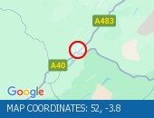 Description: A40Both directionsLlandoveryImprovement work1 lane closed27/07/26-11/08/26 2000-0600 :, Start time: 27/07/2026 20:00 , End Date: 11/08/2026 6:00, Severity: Moderate, Source: Welsh Government, Last updated: 27/07/2026 20:00
Nearest town: 7.85 miles from Bethlehem. CLEARED @ 11:43
Nearest town: 7.85 miles from Bethlehem. CLEARED @ 11:43
There are no current incidents in this location.


 National Highways England
 Transport for London (TFL)
 Traffic Wales
 Traffic Scotland
 YOUR AD HERE