Traffic incidents
The following traffic incidents and congestion for M4 have been reported by Highways England, Traffic Scotland, Traffic Wales or Transport for London (TfL) in the last two hours:
J48 HENDY TO J49 PONT ABRAHAM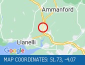 Description: M4WestboundJ48 (Pontarddulais) Hendy to J49 Pont Abraham05/08/26-06/08/26 2000-0600RoadworksClosedDiversions in place :,Start time: 05/08/2026 20:00 ,End Date:06/08/2026 6:00,Severity: Road closure,Source: Welsh Government, Last updated: 02/08/2026 18:05
Nearest town: 0.44m from Fforest.J38 MARGAM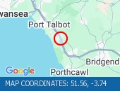 Description: M4WestboundJ38 (Port Talbot) Margam04/08/26-05/08/26 1900-0100Cyclic maintenanceClosedDiversions in place :,Start time: 04/08/2026 19:00 ,End Date:05/08/2026 1:00,Severity: Road closure,Source: Welsh Government, Last updated: 02/08/2026 18:01
Nearest town: 0.13m from Margam.J43 LLANDARCY TO J42 EARLSWOOD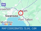 Description: M4EastboundJ43 (Neath) Llandarcy to J42 (Swansea) Earlswood04/08/26-05/08/26 2000-0600RoadworksClosedDiversions in place :,Start time: 04/08/2026 20:00 ,End Date:05/08/2026 6:00,Severity: Road closure,Source: Welsh Government, Last updated: 02/08/2026 18:03
Nearest town: 0.62m from Llandarcy.J43 LLANDARCY TO J42 EARLSWOODDescription: M4Both directionsJ43 (Neath) Llandarcy to J42 (Swansea) Earlswood05/08/26-06/08/26 2000-0600RoadworksClosedDiversions in place :,Start time: 05/08/2026 20:00 ,End Date:06/08/2026 6:00,Severity: Road closure,Source: Welsh Government, Last updated: 02/08/2026 18:04
Nearest town: 0.62m from Llandarcy.J32 CORYTON TO J29 CASTLETON Description: M4EastboundJ32 (Cardiff) Coryton to J29 (Cardiff) Castleton06/08/26-07/08/26 1930-0600ClosedDiversions in place :,Start time: 06/08/2026 19:30 ,End Date:07/08/2026 6:00,Severity: Road closure,Source: Welsh Government, Last updated: 01/08/2026 13:00
Nearest town: 0.48m from Lisvane.
Nearest town: 0.44m from Fforest.
Nearest town: 0.13m from Margam.
Nearest town: 0.62m from Llandarcy.
Nearest town: 0.62m from Llandarcy.
Nearest town: 0.48m from Lisvane.
There are no current incidents in this location.


 National Highways England
 Transport for London (TFL)
 Traffic Wales
 Traffic Scotland
 YOUR AD HERE