Current traffic around Carmarthenshire
EASTBOUND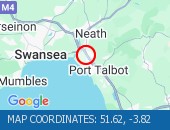 Description: M4Now clearEastboundJ42 (Swansea) Earlswood to J41 (Port Talbot) Pentyla/Baglan, Start time: 18/03/2026 17:58 , Expected end time: 18/03/2026 18:03, Severity: Moderate, Source: Welsh Government, Last updated: 18/03/2026 17:58
Nearest town: 1.92m from Port Talbot. CLEARED @ 19:18EASTBOUND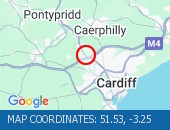 Description: M4Now clearEastboundJ32 (Cardiff) Coryton, Start time: 18/03/2026 17:59 , Expected end time: 18/03/2026 18:04, Severity: Moderate, Source: Welsh Government, Last updated: 18/03/2026 17:59
Nearest town: 1.51m from Llandaff. CLEARED @ 19:18NORTHBOUND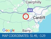 Description: A4232Now clearNorthboundA48 Interchange to M4 J33 Capel Llanilltern, Start time: 18/03/2026 18:04 , Expected end time: 18/03/2026 18:09, Severity: Moderate, Source: Welsh Government, Last updated: 18/03/2026 18:04
Nearest town: 1.37m from Peterston. CLEARED @ 19:18NORTHBOUND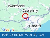 Description: A470Now clearNorthboundCoryton to Nantgarw, Start time: 18/03/2026 18:04 , Expected end time: 18/03/2026 18:09, Severity: Moderate, Source: Welsh Government, Last updated: 18/03/2026 18:04
Nearest town: 0.44m from Flynnon Taf. CLEARED @ 19:18CORYTON TO NANTGARWDescription: A470NorthboundCoryton to NantgarwCongestionDelay: s possible :, Start time: 18/03/2026 16:32 , Expected end time: 18/03/2026 19:32, Severity: Moderate, Source: Welsh Government, Last updated: 18/03/2026 16:32
Nearest town: 0.44m from Flynnon Taf. CLEARED @ 16:42J32 CORYTONDescription: M4EastboundJ32 (Cardiff) CorytonoffslipCongestionDelay: s possible :, Start time: 18/03/2026 16:36 , Expected end time: 18/03/2026 19:36, Severity: Moderate, Source: Welsh Government, Last updated: 18/03/2026 16:36
Nearest town: 1.51m from Llandaff. CLEARED @ 16:42A48 INTERCHANGE TO M4 J33 CAPEL LLANILLTERNDescription: A4232NorthboundA48 Interchange to M4 J33 Capel LlanillternCongestionDelay: s possible :, Start time: 18/03/2026 16:02 , Expected end time: 18/03/2026 20:01, Severity: Moderate, Source: Welsh Government, Last updated: 18/03/2026 16:02
Nearest town: 1.37m from Peterston. CLEARED @ 16:18J42 EARLSWOOD TO J41 PENTYLA/BAGLANDescription: M4EastboundJ42 (Swansea) Earlswood to J41 (Port Talbot) Pentyla/BaglanCongestionDelay: s possible :, Start time: 18/03/2026 15:55 , Expected end time: 18/03/2026 19:55, Severity: Moderate, Source: Welsh Government, Last updated: 18/03/2026 15:55
Nearest town: 1.92m from Port Talbot. CLEARED @ 16:06J37 PYLE TO J42 EARLSWOOD Description: M4Both directionsJ37 (Porthcawl) Pyle to J42 (Swansea) EarlswoodCyclic maintenance1 lane closed on M4Entry/Exit slip roads closedDiversions in place25/01/26-01/04/26 2000-0600 :, Start time: 25/01/2026 20:00 , End Date: 01/04/2026 6:00, Severity: Moderate, Source: Welsh Government, Last updated: 25/01/2026 20:00
Nearest town: 1.18m from Margam. CLEARED @ 15:30ABERYSTWYTH COMMINS COCH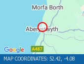 Description: A487Both directionsAberystwyth Commins CochImprovement workTemporary traffic lights02/02/26-23/06/26 0900-1600 :, Start time: 02/02/2026 9:00 , End Date: 23/06/2026 16:00, Severity: Moderate, Source: Welsh Government, Last updated: 02/02/2026 9:00
Nearest town: 0.73m from Aberystwyth. CLEARED @ 15:30LLANDOVERY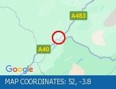 Description: A483Both directionsLlandoveryResurfacing workRoad closedDiversions in place07/03/26-22/03/26 0800-1700 :, Start time: 07/03/2026 8:00 , End Date: 22/03/2026 17:00, Severity: Road closure, Source: Welsh Government, Last updated: 07/03/2026 8:00
Nearest town: 4.77m from Halfway. CLEARED @ 15:30J36 SARN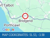 Description: M4EastboundJ36 (Bridgend) SarnCyclic maintenanceOnslip closedDiversions in place02/03/26-21/03/26 2000-0600 :, Start time: 02/03/2026 20:00 , End Date: 21/03/2026 6:00, Severity: Road closure, Source: Welsh Government, Last updated: 02/03/2026 20:00
Nearest town: 1.91m from Bridgend. CLEARED @ 15:30J36 SARNDescription: M4EastboundJ36 (Bridgend) SarnRoadworksEntry slip road closedDiversions in place02/03/26-21/03/26 2000-0600 :, Start time: 02/03/2026 20:00 , End Date: 21/03/2026 6:00, Severity: Road closure, Source: Welsh Government, Last updated: 06/03/2026 12:20
Nearest town: 1.91m from Bridgend. CLEARED @ 15:30J40 TAIBACH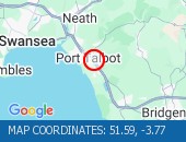 Description: M4EastboundJ40 (Port Talbot) TaibachRoadworksExit slip road closedDiversions in place02/03/26-21/03/26 0600 :, Start time: 02/03/2026 6:00 , End Date: 21/03/2026 6:00, Severity: Road closure, Source: Welsh Government, Last updated: 06/03/2026 12:26
Nearest town: 0.74m from Port Talbot. CLEARED @ 15:30ABERYSTWYTHDescription: A44Both directionsAberystwyth11/03/26-16/04/26 0900-1600Improvement workTemporary traffic lights :, Start time: 11/03/2026 9:00 , End Date: 16/04/2026 16:00, Severity: Slight, Source: Welsh Government, Last updated: 11/03/2026 9:00
Nearest town: 0.57m from Aberystwyth. CLEARED @ 15:30
Nearest town: 1.92m from Port Talbot. CLEARED @ 19:18
Nearest town: 1.51m from Llandaff. CLEARED @ 19:18
Nearest town: 1.37m from Peterston. CLEARED @ 19:18
Nearest town: 0.44m from Flynnon Taf. CLEARED @ 19:18
Nearest town: 0.44m from Flynnon Taf. CLEARED @ 16:42
Nearest town: 1.51m from Llandaff. CLEARED @ 16:42
Nearest town: 1.37m from Peterston. CLEARED @ 16:18
Nearest town: 1.92m from Port Talbot. CLEARED @ 16:06
Nearest town: 1.18m from Margam. CLEARED @ 15:30
Nearest town: 0.73m from Aberystwyth. CLEARED @ 15:30
Nearest town: 4.77m from Halfway. CLEARED @ 15:30
Nearest town: 1.91m from Bridgend. CLEARED @ 15:30
Nearest town: 1.91m from Bridgend. CLEARED @ 15:30
Nearest town: 0.74m from Port Talbot. CLEARED @ 15:30
Nearest town: 0.57m from Aberystwyth. CLEARED @ 15:30
There are no current incidents in this location.


 National Highways England
 Transport for London (TFL)
 Traffic Wales
 Traffic Scotland
 YOUR AD HERE