Current traffic around The Square
The following traffic incidents and congestion for The Square have been reported by Highways England, Traffic Scotland, Traffic Wales or Transport for London (TfL) in the last two hours:
BRIDGE CLOSED LOCAL LANES CLOSED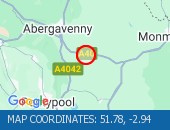 Description:Both directionsAbergavenny Hardwick R/bout to RaglanBridge closed Local lanes closed06/07/26-14/09/26 0600 :, Start time: 06/07/2026 6:00 , End Date: 14/09/2026 6:00, Severity: Road closure, Source: Welsh Government, Last updated: 07/07/2026 13:20
Nearest town: 10.01 miles from The Square. CLEARED @ 06:30LANE CLOSED: SINGLE ALTERNATE LINE TRAFFIC; ROADWORKS Single alternate line traffic; Roadworks
Nearest town: 11.76 miles from The Square.
Nearest town: 10.01 miles from The Square. CLEARED @ 06:30
Nearest town: 11.76 miles from The Square.
There are no current incidents in this location.


 National Highways England
 Transport for London (TFL)
 Traffic Wales
 Traffic Scotland
 YOUR AD HERE