Current traffic around Rock
The following traffic incidents and congestion for Rock have been reported by Highways England, Traffic Scotland, Traffic Wales or Transport for London (TfL) in the last two hours:
J27 HIGH CROSS TO J26 MALPAS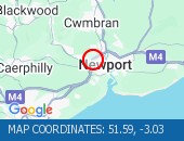 Description: M4EastboundJ27 (High Cross) High Cross to J26 (Newport) MalpasCongestionDelay: s possible :, Start time: 01/08/2026 11:02 , Expected end time: 01/08/2026 17:02, Severity: Moderate, Source: Welsh Government, Last updated: 01/08/2026 11:02
Nearest town: 9.39 miles from Rock. CLEARED @ 12:30PONTYPRIDD ALBION FOOTBRIDGE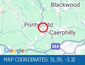 Description: A470Both directionsPontypridd Albion FootbridgeResurfacing workRoad closedDiversions in place02/08/26-30/08/26 0600-2355 :, Start time: 02/08/2026 6:00 , End Date: 30/08/2026 23:55, Severity: Road closure, Source: Welsh Government, Last updated: 23/07/2026 15:16
Nearest town: 7.61 miles from Rock. CLEARED @ 12:30
Nearest town: 9.39 miles from Rock. CLEARED @ 12:30
Nearest town: 7.61 miles from Rock. CLEARED @ 12:30
There are no current incidents in this location.


 National Highways England
 Transport for London (TFL)
 Traffic Wales
 Traffic Scotland
 YOUR AD HERE