Traffic Bethasda

SLIGHT
SEVERE
FULL SCREEN UPDATED: 18:41
×
×

Current traffic around Bethasda

The following traffic incidents and congestion for Bethasda have been reported by Highways England, Traffic Scotland, Traffic Wales or Transport for London (TfL) in the last two hours:

BRITANNIA BRIDGE
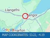
Description: A55Both directionsBritannia Bridge1 lane closedSlow moving vehicles04/11/26-06/11/26 2000-0300 :, Start time: 04/11/2026 20:00 , End Date: 06/11/2026 3:00, Severity: Moderate, Source: Welsh Government, Last updated: 28/10/2026 10:53
Nearest town: 5.79 miles from Bethasda.
J12 TAL Y BONT TO J11 LLYS Y GWYNT - WESTBOUND / EASTBOUND – LANE 1 (INCL STAGGERED CLOSURES ON ALL SLIPS AT J11 AND J12) 28/10/26-30/10/26 1900-0600 :
Description: A55Both directionsJ12 Tal y Bont to J11 Llys y Gwynt - westbound / eastbound Lane 1 (incl staggered closures on all slips at J11 and J12) 28/10/26-30/10/26 1900-0600 :, Start time: 28/10/2026 19:00 , End Date: 30/10/2026 6:00, Severity: Road closure, Source: Welsh Government, Last updated: 28/10/2026 19:00
Nearest town: 3.6 miles from Bethasda.
J8 AEL Y BOWL TO J8A CARREG BRAN
Description: A55EastboundJ8 Ael y Bowl to J8A Carreg BranRoad closedEntry slip road closedDiversions in place03/11/26 2000-0200 :, Start time: 03/11/2026 20:00 , End Date: 03/11/2026 2:00, Severity: Road closure, Source: Welsh Government, Last updated: 28/10/2026 12:08
Nearest town: 6.14 miles from Bethasda.


There are no current incidents in this location.

Roadworks


Traffic in Nearby Villages

Bethasda


Let's Get Social

Get in touch with us or stay up to date with our latest news and updates.

Follow us on Facebook See Traffic Update on Twitter See our Pinterest Images View our Blog

Live Email Traffic Alerts

Get live email alerts whenever there is a traffic incident or roadworks on the on the roads you travel that may cause congestion or jams.

Sign up for free alerts

LEGAL NOTICE

Please remember that it is against the law to use your mobile phone, tablet or any electronic device without a hands-free kit whilst driving. If you're caught by the police using any device that can send or receive data whilst driving or riding a motorcyle you'll get an automatic fixed penalty notice, 6 points on your licence and a fine of £200. A court could also disqualify you from driving.

Elsewhere on the web:

National Highways TrafficNational Highways England

Official source of traffic updates.

Transport for LondonTransport for London (TFL)

Transport for London's (TfL) portal for transportation in London.

Traffic WalesTraffic Wales

The Welsh government's traffic information service for Wales.

Traffic ScotlandTraffic Scotland

Live traffic conditions and news for Scotland's road network.

Advertise on Traffic UpdateYOUR AD HERE

Advertise to millions of motorists, holidaymakers and commuters.

Description: A55 : Both directions : Britannia Bridge : 1 lane closed : Slow moving vehicles : 04/11/26-06/11/26 2000-0300 :, Start time: 04/11/2026 20:00 , End Date: 06/11/2026 3:00, Severity: Moderate, Source: Welsh Government, Last updated: 28/10/2026 10:53
Nearest town: 5.79 miles from Bethasda.

53.22--4.19

Description: A55 : Both directions : J12 Tal y Bont to J11 Llys y Gwynt - westbound / eastbound Lane 1 (incl staggered closures on all slips at J11 and J12) 28/10/26-30/10/26 1900-0600 :, Start time: 28/10/2026 19:00 , End Date: 30/10/2026 6:00, Severity: Road closure, Source: Welsh Government, Last updated: 28/10/2026 19:00
Nearest town: 3.6 miles from Bethasda.

53.22--4.05

Description: A55 : Eastbound : J8 Ael y Bowl to J8A Carreg Bran : Road closed : Entry slip road closed : Diversions in place : 03/11/26 2000-0200 :, Start time: 03/11/2026 20:00 , End Date: 03/11/2026 2:00, Severity: Road closure, Source: Welsh Government, Last updated: 28/10/2026 12:08
Nearest town: 6.14 miles from Bethasda.

53.22--4.19