M1 Northbound - Accident×
 Accident
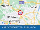
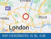
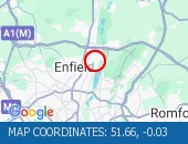
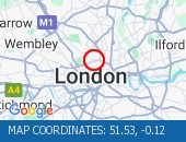
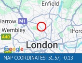
 Location : The M1 northbound between junctions J1 (North Circular) and J4 (Edgware A41) .
Lane Closures : The hard shoulder, lanes 1 and 2 are closed.
Reason : Road traffic collision.
Status : Currently Active.
Time To Clear : The event is expected to clear between 21:30 and 21:45 on 27/04/2024.
Return To Normal : Normal traffic conditions are expected between 21:30 and 21:45 on 27/04/2024.
Lanes Closed : There are two of three lanes closed.
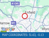
CLEARED @ 20:14Location:
M1, 1.13m of
Edgware,
Greater London Authority
Street View M1 camera (Streetview):
Don't get stuck in traffic when you're out and about. Use our SMS service to get the latest traffic conditions instantly to your mobile phone.
M25 Southbound - Accident×
 Accident
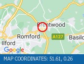
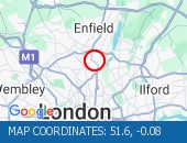
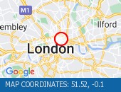
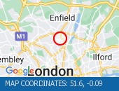
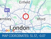
 Location : The M25 anticlockwise at junction J28 (Chelmsford) .
Lane Closures : The hard shoulder and lane 1 are closed.
Reason : Road traffic collision.
Status : Currently Active.
Time To Clear : The event is expected to clear between 20:45 and 21:00 on 27/04/2024.
Return To Normal : Normal traffic conditions are expected between 20:45 and 21:00 on 27/04/2024.
Lanes Closed : There is one of three lanes closed.
CLEARED @ 19:56Location:
M25, 2.11m of
Harold Wood,
Greater London Authority
Street View M25 camera (Streetview):
Factory Road All Directions - Albert Road junction with×
 Albert Road junction with Savi
 Albert Road junction with Saville Road (All Directions): There is a reported building fire at this location. All restrictions have now been lifted. There are no reports of congestion in the area.
Location: Factory Road, 2.15m of
Blackwall,
Greater London
Street View Factory Road camera (Streetview):
Blackwall Tunnel (Southbound Bore) South - Blackwall Tunnel (Southbo×
 Blackwall Tunnel (Southbound B
 Blackwall Tunnel (Southbound Bore) (Southbound): the broken down motorcycle in the tunnel has been removed. All congestion resulting from this broken down vehicle has cleared (although tailback remain at the present time - see separate entry).
Location: Blackwall Tunnel (Southbound Bore), 0.69m of
Blackwall,
Greater London
Street View Blackwall Tunnel (Southbound Bore) camera (Streetview):
Ripple Road East Bound - Ripple Road (Eastbound) -×
 Ripple Road (Eastbound) - Lane
 Ripple Road (Eastbound) - Lane three (of three) blocked due to a broken down vehicle. The accident has been cleared and lane three has been reopened to traffic. Traffic flows are returning to normal for the time of day.
Location: Ripple Road, 1.69m of
Barking,
Greater London
Street View Ripple Road camera (Streetview):
Limehouse Link All Directions - Limehouse Link Tunnel (We×
 Limehouse Link Tunnel (Westbou
 Limehouse Link Tunnel (Westbound) Lane one is blocked by a broken down vehicle. The vehicle has now been removed - all lanes are open.
Location: Limehouse Link, 0.56m of
Limehouse,
Greater London
Street View Limehouse Link camera (Streetview):
Limehouse Link Tunnel Both Directions - Limehouse Link Tunnel (Bo×
 Limehouse Link Tunnel (Both Di
 Limehouse Link Tunnel (Both Directions) - Closure overnight to facilitate works
Location: Limehouse Link Tunnel, 0.47m of
Limehouse,
Greater London
Street View Limehouse Link Tunnel camera (Streetview):
North Circular Road All Directions - Bowes Road (North Circula×
 Bowes Road (North Circular Roa
 Bowes Road (North Circular Road) (All Directions) - The traffic signals are not operating under central computer control at this junction. Traffic signals at this location are now on and working.
Location: North Circular Road, 0.51m of
Palmers Green,
Greater London
Street View North Circular Road camera (Streetview):
Walthamstow Avenue (North Circular Road) - Walthamstow Avenue (North×
 Walthamstow Avenue (North Circ
 Walthamstow Avenue (North Circular Road) (Eastbound) On approach to the Crooked Billet Roundabout. Partial restriction of the off slip towards the roundabout due to an accident. The collision has been cleared. All lanes are open.
Location: Walthamstow Avenue (North Circular Road), 0.52m of
Walthamstow,
Greater London
Street View Walthamstow Avenue (North Circular Road) camera (Streetview):
Leonard Street All Directions - City Road (All Directions×
 City Road (All Directions) at
 City Road (All Directions) at the junction of Leonard Street - Temporary traffic signals in operation to facilitate road works. No restrictions in place - Traffic light and flowing well
Location: Leonard Street, 0.64m of
Shoreditch,
Greater London
Street View Leonard Street camera (Streetview):
Alie Street All Directions - Leman Street (Southbound)×
 Leman Street (Southbound) at t
 Leman Street (Southbound) at the junction of Alie Street - lane closure to facilitate new water connection to property by Thames Water. No visible restrictions in place.
Location: Alie Street, 0.91m of
Whitechapel,
Greater London
Street View Alie Street camera (Streetview):
Limehouse Link Tunnel East Bound - Limehouse Link Tunnel (Ea×
Limehouse Link Tunnel (Eastbou Limehouse Link Tunnel (Eastbound) - lane one blocked due to broken down car. Vehicle has now been recovered. All lanes now reopen. Traffic flowing well.
Location: Limehouse Link Tunnel, 0.56m of
Limehouse,
Greater London
Street View Limehouse Link Tunnel camera (Streetview):
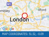
Harrington Square All Directions - Hampstead Road junction w×
 Hampstead Road junction with H
 Hampstead Road junction with Harrington Square (Southbound): There is a low defective road sign at this location. The sign has now been made safe.
Location: Harrington Square, 1.55m of
Bloomsbury,
Greater London
Street View Harrington Square camera (Streetview):
Stoke Newington Church Street All Direct - Stoke Newington High Stre×
 Stoke Newington High Street (B
 Stoke Newington High Street (Both Directions) at the junction of Stoke Newington Church Street. Traffic lights are working. Traffic signals are on and working. Traffic is moving well.
Location: Stoke Newington Church Street, 0.48m of
Stoke Newington,
Greater London
Street View Stoke Newington Church Street camera (Streetview):
Bruce Grove All Directions - Lordship Lane (All Direct×
 Lordship Lane (All Directions)
 Lordship Lane (All Directions) at the junction of Bruce Grove - Temporary traffic lights in place due to water works Traffic is flowing well in the area.
Location: Bruce Grove, 0.38m of
Edmonton,
Greater London
Street View Bruce Grove camera (Streetview):
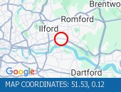
Westbury Road All Directions - Romford Road (Both Direct×
 Romford Road (Both Directions)
 Romford Road (Both Directions) between Upton Lane and Green Street - Romford Road has reopened in both directions Romford Road has reopened in both directions, and vehicles that remain parked at the scene are not causing an obstruction. Traffic is flowing normally.
Location: Westbury Road, 0.9m of
Ilford,
Greater London
Street View Westbury Road camera (Streetview):
Crownfield Road All Directions - Crownfield Road (All Dire×
 Crownfield Road (All Direction
 Crownfield Road (All Directions) at the junction of A112 Leyton High Road - Temporary signals in operation due to bus shelter upgrade works. (Sundays Only)
Location: Crownfield Road, 1.29m of
Stratford,
Greater London
Street View Crownfield Road camera (Streetview):
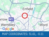
Goldsdown Close All Directions - Green Street (All Directi×
 Green Street (All Directions)
 Green Street (All Directions) at the junction of Jute Lane - The level crossing barriers are now working. Fault now repaired.
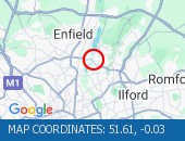
Location: Goldsdown Close, 1.58m of
Enfield,
Greater London
Street View Goldsdown Close camera (Streetview):
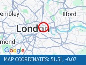
East Poultry Avenue All Directions - Charterhouse Street (Both×
 Charterhouse Street (Both Dire
 Charterhouse Street (Both Directions) between St John Street and East Poultry Avenue - full closure due to crane operation on weekends only. Drivers are advised to use an alternative route when closures are in place. Road remains open at present.
Location: East Poultry Avenue, 0.61m of
Bloomsbury,
Greater London
Street View East Poultry Avenue camera (Streetview):
Blackwall Tunnel Northern Approach All D - Blackwall Tunnel Northern×
 Blackwall Tunnel Northern Appr
 Blackwall Tunnel Northern Approach (Southbound) at the junction of East India Dock Road - Congestion due cleared. A12 Southbound traffic flows have returned to normal for the time of day.
Location: Blackwall Tunnel Northern Approach, 0.47m of
Blackwall,
Greater London
Street View Blackwall Tunnel Northern Approach camera (Streetview):
Viking Gardens All Directions - Newham Way (Eastbound) at×
 Newham Way (Eastbound) at the
 Newham Way (Eastbound) at the junction of Noel Road - All lanes now open. All lanes now open.
Location: Viking Gardens, 0.95m of
East Ham,
Greater London
Street View Viking Gardens camera (Streetview):
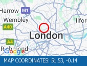
Argyle Street All Directions - Euston Road (Westbound) a×
 Euston Road (Westbound) at the
 Euston Road (Westbound) at the junction of Argyle Street - Lane one closed overnight to facilitate subway works.
Location: Argyle Street, 0.96m of
Bloomsbury,
Greater London
Street View Argyle Street camera (Streetview):
Crestfield Street All Directions - Euston Road (Eastbound) a×
Euston Road (Eastbound) at the Euston Road (Eastbound) at the junction of Crestfield Street - Lane one closed overnight outside Kings Cross station to facilitate pavement works.
Location: Crestfield Street, 0.98m of
Bloomsbury,
Greater London
Street View Crestfield Street camera (Streetview):
The Roundway All Directions - Lordship Lane (All Direct×
 Lordship Lane (All Directions)
 Lordship Lane (All Directions) at the junction of The Roundway - Collision - Lordship Lane is blocked eastbound -Slow moving traffic on approach All roads have reopened. Traffic is flowing well.
Location: The Roundway, 1.07m of
Wood Green,
Greater London
Street View The Roundway camera (Streetview):
Angel Road (North Circular Road) All Dir - Angel Road (North Circula×
 Angel Road (North Circular Roa
 Angel Road (North Circular Road) (All Directions) at the junction of the Cooks Ferry Flyover - The A406 has been fully reopened eastbound with one lane reopened in the westbound carriageway. All lanes open with traffic flowing well.
Location: Angel Road (North Circular Road), 0.92m of
Walthamstow,
Greater London
Street View Angel Road (North Circular Road) camera (Streetview):
Heathcroft Gardens All Directions - Southend Road (North Circ×
 Southend Road (North Circular
 Southend Road (North Circular Road) at the junction of Wadham Road - All lanes are now open. All lanes are now open. Traffic is flowing well.
Location: Heathcroft Gardens, 1.36m of
Walthamstow,
Greater London
Street View Heathcroft Gardens camera (Streetview):
Station Parade All Directions - Southgate Circus junction×
 Southgate Circus junction with
 Southgate Circus junction with Chase Side(All Directions) There is a collision at this location. Traffic is flowing well.
Location: Station Parade, 1.63m of
Palmers Green,
Greater London
Street View Station Parade camera (Streetview):
Nurse Close All Directions - Watling Avenue (All Direc×
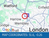 Watling Avenue (All Directions
 Watling Avenue (All Directions) at the junction of Orange Hill Road . Traffic signals have been restored. Traffic signals have been restored.
Location: Nurse Close, 0.27m of
Edgware,
Greater London
Street View Nurse Close camera (Streetview):
Threadneedle Street East Bound - Threadneedle Street (East×
 Threadneedle Street (Eastbound
 Threadneedle Street (Eastbound) at the junction of Bishopsgate - A parked lorry is causing an obstruction. Broken down vehicle has been moved. Traffic flowing well.
Location: Threadneedle Street, 0.99m of
Finsbury,
Greater London
Street View Threadneedle Street camera (Streetview):
City Road All Directions - The road will be closed n×
The road will be closed northb The road will be closed northbound with a contra flow in operation. City Road is open in both directions - Traffic is light and flowing well
Location: City Road, 0.88m of
Shoreditch,
Greater London
Street View City Road camera (Streetview):
Jardine Road All Directions - Rotherhithe Tunnel (North×
Rotherhithe Tunnel (Northbound Rotherhithe Tunnel (Northbound) there is a broken down vehicle paritally blocking the road. Approach with care. The tunnel has been opened in both directions. Traffic is light and flowing well in the area.
Location: Jardine Road, 0.53m of
Whitechapel,
Greater London
Street View Jardine Road camera (Streetview):
Bow Common Lane All Directions - St Paul's Way (Both D×
 St Paul's Way (Both Direct
 St Paul's Way (Both Directions) between Burgess Street and Bow Common Lane - Road closure to facilitate roadworks No restrictions in place.
Location: Bow Common Lane, 0.45m of
Limehouse,
Greater London
Street View Bow Common Lane camera (Streetview):
Omega Place All Directions - Caledonian Road (Southbou×
Caledonian Road (Southbound) a Caledonian Road (Southbound) at the junction of Omega Place - Lane restrictions to facilitate water works No restrictions in the area. Traffic is free flowing.
Location: Omega Place, 0.91m of
Islington,
Greater London
Street View Omega Place camera (Streetview):
Junction Road All Directions - Archway Road (All Directi×
 Archway Road (All Directions)
 Archway Road (All Directions) at the junction of Tollhouse Way - Signal upgrade works. Expect delays when restrictions in operation. Works are currently confined to the footways and central reservations.
Location: Junction Road, 2.21m of
Stoke Newington,
Greater London
Street View Junction Road camera (Streetview):
Clapton Common All Directions - Stamford Hill (All Direct×
 Stamford Hill (All Directions)
 Stamford Hill (All Directions) at the junction of Clapton Common - Traffic signals are out of order. Traffic flows have returned to normal.
Location: Clapton Common, 0.66m of
Stoke Newington,
Greater London
Street View Clapton Common camera (Streetview):
 Highways Agency
 The AA
 Traffic Cymru
 Traffic Scotland
 YOUR AD HERE