 AuthorityOperation Location : The M25 clockwise between junctions J15 (Slough) and J16 (M40) .
Reason : Police incident.
Status : Currently Active.
Time To Clear : The event is expected to clear between 19:45 and 20:00 on 19/12/2025.
Return To Normal : Normal traffic conditions are expected between 19:45 and 20:00 on 19/12/2025.
Lanes Closed : All lanes are closed.
AuthorityOperation Location : The M25 clockwise between junctions J15 (Slough) and J16 (M40) .
Reason : Police incident.
Status : Currently Active.
Time To Clear : The event is expected to clear between 19:45 and 20:00 on 19/12/2025.
Return To Normal : Normal traffic conditions are expected between 19:45 and 20:00 on 19/12/2025.
Lanes Closed : All lanes are closed. 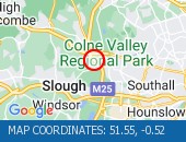 AuthorityOperation Location : The M25 anticlockwise between junctions J16 (M40) and J15 (Slough) .
Reason : Police incident.
Status : Currently Active.
Time To Clear : The event is expected to clear between 19:15 and 19:30 on 19/12/2025.
Return To Normal : Normal traffic conditions are expected between 20:15 and 20:30 on 19/12/2025.
Delay : There are currently delays of 10 minutes against expected traffic.
Lanes Closed : All lanes are closed.
AuthorityOperation Location : The M25 anticlockwise between junctions J16 (M40) and J15 (Slough) .
Reason : Police incident.
Status : Currently Active.
Time To Clear : The event is expected to clear between 19:15 and 19:30 on 19/12/2025.
Return To Normal : Normal traffic conditions are expected between 20:15 and 20:30 on 19/12/2025.
Delay : There are currently delays of 10 minutes against expected traffic.
Lanes Closed : All lanes are closed. 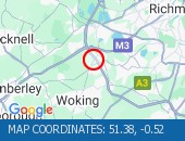 Vehicle Recovery Location : The M25 clockwise between junctions J11 (Chertsey) and J12 (Basingstoke) .
Lane Closures : The hard shoulder and lane 1 are closed.
Reason : Vehicle tyre change.
Status : Currently Active.
Time To Clear : The event is expected to clear between 16:15 and 16:30 on 19/12/2025.
Return To Normal : Normal traffic conditions are expected between 16:15 and 16:30 on 19/12/2025.
Lanes Closed : There is one of four lanes closed.
Vehicle Recovery Location : The M25 clockwise between junctions J11 (Chertsey) and J12 (Basingstoke) .
Lane Closures : The hard shoulder and lane 1 are closed.
Reason : Vehicle tyre change.
Status : Currently Active.
Time To Clear : The event is expected to clear between 16:15 and 16:30 on 19/12/2025.
Return To Normal : Normal traffic conditions are expected between 16:15 and 16:30 on 19/12/2025.
Lanes Closed : There is one of four lanes closed. 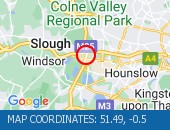 Vehicle Fire Location : The M25 anticlockwise between junctions J15 (Slough) and J14 (Heathrow Airport) .
Lane Closures : The hard shoulder and lane 1 are closed.
Reason : Vehicle fire.
Status : Currently Active.
Time To Clear : The event is expected to clear between 18:45 and 19:00 on 19/12/2025.
Return To Normal : Normal traffic conditions are expected between 18:45 and 19:00 on 19/12/2025.
Lanes Closed : There is one of six lanes closed.
Vehicle Fire Location : The M25 anticlockwise between junctions J15 (Slough) and J14 (Heathrow Airport) .
Lane Closures : The hard shoulder and lane 1 are closed.
Reason : Vehicle fire.
Status : Currently Active.
Time To Clear : The event is expected to clear between 18:45 and 19:00 on 19/12/2025.
Return To Normal : Normal traffic conditions are expected between 18:45 and 19:00 on 19/12/2025.
Lanes Closed : There is one of six lanes closed. 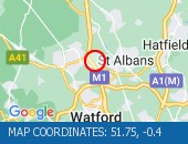 Broken down vehicle Location : The M1 northbound between junctions J6 (Watford A405) and J8 (Hemel Hstead) .
Reason : Broken down vehicle.
Status : Cleared.
Broken down vehicle Location : The M1 northbound between junctions J6 (Watford A405) and J8 (Hemel Hstead) .
Reason : Broken down vehicle.
Status : Cleared.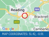 Broken down vehicle Location : The M4 westbound between junctions J10 (Reading) and J11 (Basingstoke) .
Lane Closures : The hard shoulder and lane 1 are closed.
Reason : Broken down vehicle.
Status : Currently Active.
Time To Clear : The event is expected to clear between 19:45 and 20:00 on 19/12/2025.
Return To Normal : Normal traffic conditions are expected between 19:45 and 20:00 on 19/12/2025.
Lanes Closed : There is one of four lanes closed.
Broken down vehicle Location : The M4 westbound between junctions J10 (Reading) and J11 (Basingstoke) .
Lane Closures : The hard shoulder and lane 1 are closed.
Reason : Broken down vehicle.
Status : Currently Active.
Time To Clear : The event is expected to clear between 19:45 and 20:00 on 19/12/2025.
Return To Normal : Normal traffic conditions are expected between 19:45 and 20:00 on 19/12/2025.
Lanes Closed : There is one of four lanes closed.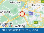 Accident Location : The M25 anticlockwise at junction J12 (Basingstoke) .
Lane Closures : Lane three is closed.
Reason : Road traffic collision.
Status : Currently Active.
Time To Clear : The event is expected to clear between 20:15 and 20:30 on 19/12/2025.
Return To Normal : Normal traffic conditions are expected between 20:15 and 20:30 on 19/12/2025.
Lanes Closed : There is one of three lanes closed.
Accident Location : The M25 anticlockwise at junction J12 (Basingstoke) .
Lane Closures : Lane three is closed.
Reason : Road traffic collision.
Status : Currently Active.
Time To Clear : The event is expected to clear between 20:15 and 20:30 on 19/12/2025.
Return To Normal : Normal traffic conditions are expected between 20:15 and 20:30 on 19/12/2025.
Lanes Closed : There is one of three lanes closed.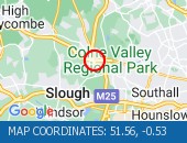 Broken down vehicle Location : The M25 anticlockwise at junction J16 (M40) .
Lane Closures : The hard shoulder and lane 1 are closed.
Reason : Broken down vehicle.
Status : Currently Active.
Time To Clear : The event is expected to clear between 20:00 and 20:15 on 19/12/2025.
Return To Normal : Normal traffic conditions are expected between 20:00 and 20:15 on 19/12/2025.
Lanes Closed : There is one of three lanes closed.
Broken down vehicle Location : The M25 anticlockwise at junction J16 (M40) .
Lane Closures : The hard shoulder and lane 1 are closed.
Reason : Broken down vehicle.
Status : Currently Active.
Time To Clear : The event is expected to clear between 20:00 and 20:15 on 19/12/2025.
Return To Normal : Normal traffic conditions are expected between 20:00 and 20:15 on 19/12/2025.
Lanes Closed : There is one of three lanes closed.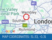 Western Avenue (Eastbound) nea Western Avenue (Eastbound) near the junction with Alperton Lane - Collision - Lane one reopened. Traffic is flowing well for the time of day.
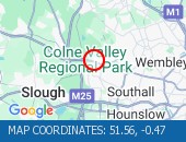 Swakeleys Roundabout - There i Swakeleys Roundabout - There is a broken down car on the eastbound on slip road to the A40. All lanes are open.
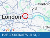 Blackwall Tunnel (Southbound B Blackwall Tunnel (Southbound Bore) (Southbound): the broken down motorcycle in the tunnel has been removed. All congestion resulting from this broken down vehicle has cleared (although tailback remain at the present time - see separate entry).
 Cross Deep (All Directions) ju Cross Deep (All Directions) junction with Grotto Road. All closures have been removed - Traffic flows have returned to normal in the area
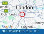 The Avenue (Southbound) at the The Avenue (Southbound) at the junction of Windmill Drive - Lane one restrictions with single alternate lane traffic controlled by STOP / GO boards for BT works. Traffic is flowing well in the area.
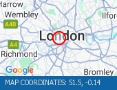 Victoria Street (Westbound) b Victoria Street (Westbound) between Artillery Row and Bressenden Place. There will be a westbound closure to facilitate drainage works.
 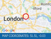 Limehouse Link Tunnel (Westbou Limehouse Link Tunnel (Westbound) Lane one is blocked by a broken down vehicle. The vehicle has now been removed - all lanes are open.
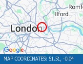 Limehouse Link Tunnel (Both Di Limehouse Link Tunnel (Both Directions) - Closure overnight to facilitate works
 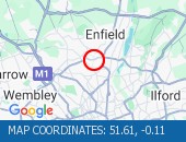 Bowes Road (North Circular Roa Bowes Road (North Circular Road) (All Directions) - The traffic signals are not operating under central computer control at this junction. Traffic signals at this location are now on and working.
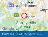 Leatherhead Road (Northbound). Leatherhead Road (Northbound). Traffic is moving well. Traffic is moving well.
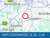 Middleton Road (Both Direction Middleton Road (Both Directions) between Bishopsford Road and St Helier Avenue - road closure to facilitate carriageway resurfacing. Local diversion in place.
 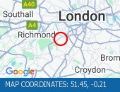 West Hill (westbound) between West Hill (westbound) between Keswick Road and Portinscale Road. Partial lane one restriction. All lanes have reopened on West Hill -Works are complete - Traffic flows have returned to normal
 Trinity Road (Both Directions) Trinity Road (Both Directions) at the junction of Eatonville Road - Temporary traffic signals will be in place to facilitate water works.
 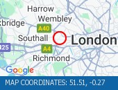 Horn Lane (All Directions) at Horn Lane (All Directions) at the junction of Rectory Road - Three-way temporary signals in operation to facilitate works by BT. Traffic is flowing well in the area.
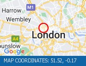 Marylebone Road (Eastbound) l Marylebone Road (Eastbound) lane one closed due to a broken down van. Vehicle has been recovered.
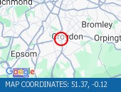 Purley Way (Northbound) betwee Purley Way (Northbound) between Whitestone Way and Commerce Way - Lane restrictions to facilitate carriageway chamber access works for new connections. (Night works only)
 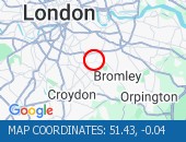 Sydenham Road (Both Directions Sydenham Road (Both Directions) at the junction of Larkbere Road - Reports of an accident at this location. Traffic is flowing well.
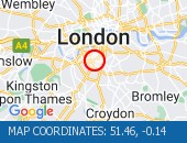 Clapham Common North Side (Eas Clapham Common North Side (Eastbound) at the junction of Long Road . Road reopened and traffic is moving well.
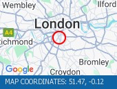 Clapham Road (Both Directions) Clapham Road (Both Directions) at the junction of Lingham Street- there is a collision at this location. Road reopened - accident cleared
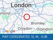 Dulwich Common (Both Direction Dulwich Common (Both Directions) at the junction of Ryecotes Mead - All lanes are now open. All lanes are now open. Traffic is flowing well in the area.
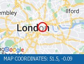 Road closed for telecoms work. Road closed for telecoms work. Diversions in operation. The tunnel remains closed. Use an alternative route.
 A4 Piccadilly (Eastbound) at t A4 Piccadilly (Eastbound) at the junction of Old Bond Street - lane restriction due in to facilitate crane operation. Currently no visible restrictions. Traffic flow is light with no delays.
 Blackfriars Underpass (Westbou Blackfriars Underpass (Westbound) - broken down vehicle removed. Vehicle removed. Traffic is moving well.
 City Road (All Directions) at City Road (All Directions) at the junction of Leonard Street - Temporary traffic signals in operation to facilitate road works. No restrictions in place - Traffic light and flowing well
 Leman Street (Southbound) at t Leman Street (Southbound) at the junction of Alie Street - lane closure to facilitate new water connection to property by Thames Water. No visible restrictions in place.
Current Incidents
Broken down vehicleLocation : The M25 anticlockwise at junction J16 (M40) .
Lane Closures : The hard shoulder and lane 1 are closed.
Reason : Broken down vehicle.
Status : Currently Active.
Time To Clear : The event is expected to clear between 20:00 and 20:15 on 19/12/2025.
Return To Normal : Normal traffic conditions are expected between 20:00 and 20:15 on 19/12/2025.
Lanes Closed : There is one of three lanes closed.
Location:
M25, 2.07m of Uxbridge, Buckinghamshire
AccidentLocation : The M25 anticlockwise at junction J12 (Basingstoke) .
Lane Closures : Lane three is closed.
Reason : Road traffic collision.
Status : Currently Active.
Time To Clear : The event is expected to clear between 20:15 and 20:30 on 19/12/2025.
Return To Normal : Normal traffic conditions are expected between 20:15 and 20:30 on 19/12/2025.
Lanes Closed : There is one of three lanes closed.
Location:
M25, 1.63m of Egham, Surrey
Broken down vehicleLocation : The M4 westbound between junctions J10 (Reading) and J11 (Basingstoke) .
Lane Closures : The hard shoulder and lane 1 are closed.
Reason : Broken down vehicle.
Status : Currently Active.
Time To Clear : The event is expected to clear between 19:45 and 20:00 on 19/12/2025.
Return To Normal : Normal traffic conditions are expected between 19:45 and 20:00 on 19/12/2025.
Lanes Closed : There is one of four lanes closed.
Location:
M4, 4.14m of Reading, Wokingham
Broken down vehicleLocation : The M1 northbound between junctions J6 (Watford A405) and J8 (Hemel Hstead) .
Reason : Broken down vehicle.
Status : Cleared.
Location:
M1, 2.71m of Hemel Hempstead, Hertfordshire
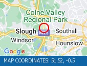
AuthorityOperationLocation : The M25 clockwise between junctions J15 (Slough) and J16 (M40) .
Reason : Police incident.
Status : Currently Active.
Time To Clear : The event is expected to clear between 19:45 and 20:00 on 19/12/2025.
Return To Normal : Normal traffic conditions are expected between 19:45 and 20:00 on 19/12/2025.
Lanes Closed : All lanes are closed. CLEARED @ 18:17
Location:
M25, 2.11m of Uxbridge, Buckinghamshire
AuthorityOperationLocation : The M25 anticlockwise between junctions J16 (M40) and J15 (Slough) .
Reason : Police incident.
Status : Currently Active.
Time To Clear : The event is expected to clear between 19:15 and 19:30 on 19/12/2025.
Return To Normal : Normal traffic conditions are expected between 20:15 and 20:30 on 19/12/2025.
Delay : There are currently delays of 10 minutes against expected traffic.
Lanes Closed : All lanes are closed. CLEARED @ 18:17
Location:
M25, 1.73m of Uxbridge, Buckinghamshire
Vehicle RecoveryLocation : The M25 clockwise between junctions J11 (Chertsey) and J12 (Basingstoke) .
Lane Closures : The hard shoulder and lane 1 are closed.
Reason : Vehicle tyre change.
Status : Currently Active.
Time To Clear : The event is expected to clear between 16:15 and 16:30 on 19/12/2025.
Return To Normal : Normal traffic conditions are expected between 16:15 and 16:30 on 19/12/2025.
Lanes Closed : There is one of four lanes closed. CLEARED @ 16:11
Location:
M25, 0.77m of Chertsey, Surrey
Vehicle FireLocation : The M25 anticlockwise between junctions J15 (Slough) and J14 (Heathrow Airport) .
Lane Closures : The hard shoulder and lane 1 are closed.
Reason : Vehicle fire.
Status : Currently Active.
Time To Clear : The event is expected to clear between 18:45 and 19:00 on 19/12/2025.
Return To Normal : Normal traffic conditions are expected between 18:45 and 19:00 on 19/12/2025.
Lanes Closed : There is one of six lanes closed. CLEARED @ 18:26
Location:
M25, 2.46m of Heathrow, Greater London Authority
AuthorityOperationLocation : The M25 anticlockwise between junctions J16 (M40) and J15 (Slough) .
Reason : Police incident.
Status : Currently Active.
Time To Clear : The event is expected to clear between 19:00 and 19:15 on 19/12/2025.
Return To Normal : Normal traffic conditions are expected between 19:00 and 19:15 on 19/12/2025.
Lanes Closed : There are lane closures. CLEARED @ 17:50
Location:
M25, 1.98m of Uxbridge, Buckinghamshire
 Highways Agency
 The AA
 Traffic Cymru
 Traffic Scotland
 YOUR AD HERE